Guadalajara Maps and Orientation
(Guadalajara, Jalisco, Mexico)
A vast city with a population of some four million people, Guadalajara is the state capital and located within Jalisco, in south-western Mexico. Guadalajara is Mexico's second city after the country's capital of Mexico City, which is sited to the north-west.
The very heart of Guadalajara is dominated by its magnificent twin-towered cathedral, which is surrounded by four large public plazas. Located on the eastern side of Guadalajara cathedral, the Plaza de la Liberación is especially notable and lies next to the Degollado Theatre. Further east, the lively pedestrianised precinct of the Plaza Tapatia leads to the Instituto Cultural de Cabanas, while to the south, you will find the Mercado Libertad, a vast three-floor market.
Maps and Orientation of the City
If you are planning to purchase a map of Guadalajara upon your arrival, a number of bookstores are situated on the corner of Juarez and the 16 de Septiembre and also on the Avenida Tepeyac, where both English-language maps and travel guides are available.
One of the most important thoroughfares in Guadalajara is the Calz Independencia, which heads north to the zoo and south towards the Old Bus Terminal, known locally as the Antigua Central Camionera. Similarly named, the Calle Independencia heads east-west, close to the cathedral itself. Also nearby and in this part of Guadalajara, the Avenida Hidalgo borders the northern side of the cathedral and connects many places of interest.
- Bosque La Primavera - west
- El Quince - south
- Las Pintas De Arriba - south
- Nuevo Mexico - north-west
- San Juan De Ocotan - north-west
- Sana Anita - south-west
- Santa Ana Tepetitlan - west
- Santa Cruz Del Valle - south
- Tequila - north-west
- Tlaquepaque - east
- Tonala - south-east
- Zapopan - north
- Zapotlanejo - east
Map of Mexico

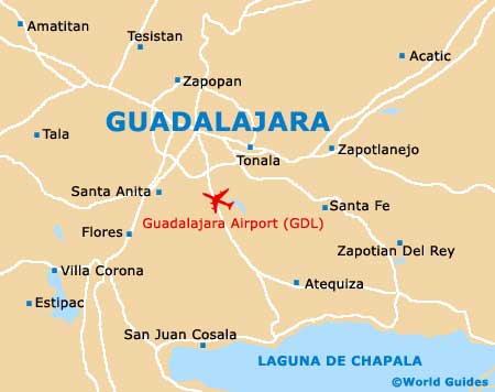
Map of Guadalajara